

Before you plan any trek, it helps to have the basic facts clear: where it is, how high it goes, how long it takes, how hard it is, what you need and when to go. This page gathers the key facts and figures about the Mardi Himal Trek in one place, with a short explanation of each so the numbers make sense. Where figures vary between sources, as altitudes and distances often do in the Himalaya, we give the most commonly used values and explain why they differ. For the full story, see the complete guide to the Mardi Himal Trek.
The Trek at a Glance
| Fact | Detail |
|---|---|
| Location | Kaski District, Gandaki Province, western Nepal, northeast of Pokhara |
| Protected area | Annapurna Conservation Area |
| Maximum altitude | Mardi Himal Base Camp, about 4,500 m |
| Highest overnight | High Camp, about 3,580 m |
| Trekking days | 3–5 from Pokhara |
| Total trip | About 7–9 days including international arrival or Kathmandu |
| Distance | Roughly 40–55 km depending on the route |
| Difficulty | Moderate; non-technical |
| Start points | Kande, Phedi or Dhampus (sometimes Siding) |
| End point | Usually Siding |
| Accommodation | Tea houses (lodges) |
| Best seasons | Autumn (Sept–Nov) and spring (Mar–May) |
| Permits | ACAP permit; TIMS card where required |
| Guide | Licensed guide required for foreign trekkers |
| Opened to trekkers | Around 2012 |
Location
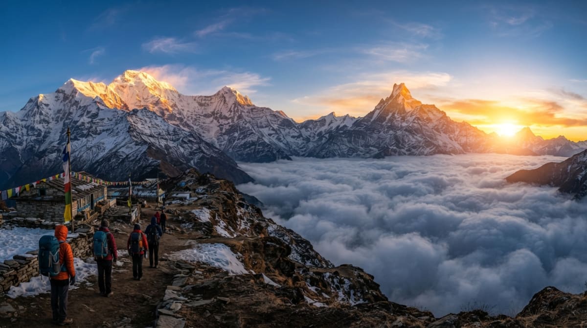
The Mardi Himal Trek lies in Kaski District, in Gandaki Province of western Nepal, on the southern flank of the Annapurna range. It follows a long ridge that runs south from the peaks of Mardi Himal and Machapuchare toward Pokhara, Nepal's second-largest tourist hub. The ridge is flanked by two river valleys: the Modi Khola to the west, which drains the Annapurna Sanctuary, and the Mardi Khola to the east. The whole route lies within the Annapurna Conservation Area, Nepal's largest protected area. Pokhara, the gateway city, is about 200 kilometers west of Kathmandu. See where Mardi Himal is and Kaski District.
Altitude
| Place | Approximate altitude |
|---|---|
| Pokhara | 822 m |
| Kande | 1,770 m |
| Pitam Deurali | 2,100 m |
| Forest Camp | 2,600 m |
| Low Camp | 2,970 m |
| High Camp | 3,580 m |
| Upper View Point | 4,200 m |
| Mardi Himal Base Camp | About 4,500 m |
The trek climbs from about 800 meters in Pokhara to about 4,500 meters at Base Camp, a gain of nearly 3,700 meters. However, you sleep no higher than High Camp, at around 3,580 meters, and reach Base Camp on a day hike, which keeps the risk of serious altitude sickness relatively low. Published altitudes vary by tens of meters between maps and GPS devices; Base Camp is often given as 4,500 meters, but figures like 4,480 or 4,496 also appear. See how high Base Camp is.
Duration
From Pokhara, the trek takes three to five days. The most popular option is five days, which allows reasonable acclimatization and comfortable daily distances. The three-day version is possible for fit trekkers but involves long days and rapid altitude gain. Including arrival and travel, most international visitors plan seven to nine days: seven if flying directly into Pokhara, nine if starting from Kathmandu. Longer versions with rest days, village stays or combinations with other treks are also popular. See how many days you need and the day-by-day itinerary.
Distance
The total walking distance is roughly 40 to 55 kilometers, depending on where you start, how far you go on summit day and which descent route you take. That may not sound far, but distance is a poor measure of effort in the mountains. Much of the trail is steep, climbing or descending over a kilometer in a day, and walking at altitude is slow. Most days involve four to seven hours on foot, with summit day often longer. See distance, duration and elevation explained and daily walking hours.
Difficulty
The Mardi Himal Trek is usually graded as moderate. It is non-technical, with no scrambling, ropes or glacier travel in normal conditions, and the trail is well defined. But it is a genuine mountain trek. The forest sections involve long, steep climbs; the ridge is exposed to wind and weather; and summit day combines an early start, cold, a steep climb of around 900 meters and altitude effects, followed by a long descent. Reasonably fit people who prepare sensibly can complete it, including many first-time trekkers. See how difficult the trek is and Nepal trek grades explained.
Start and End Points
Most itineraries start at Kande, about an hour's drive west of Pokhara on the Baglung highway, climbing to Australian Camp on the first morning. Alternatives include Phedi, with a climb to Dhampus, or driving to Dhampus directly. Most itineraries finish at Siding, a village on the eastern side of the ridge, with a jeep back to Pokhara. This makes the trek a loop that avoids retracing your steps. Some short itineraries start and finish at Siding. See Phedi vs Kande and the Siding village guide.
Permits and Rules
Because the trek lies within the Annapurna Conservation Area, all trekkers need an ACAP entry permit. For foreign nationals, the fee has been around NPR 3,000, with lower rates for SAARC nationals; fees can change, so check current rates before you travel. A TIMS card may also be required. Since April 2023, foreign trekkers in Nepal's national parks and conservation areas have been required to trek with a licensed guide, so independent trekking without a guide is no longer permitted for foreigners on this route. Permits can be arranged in Pokhara or Kathmandu, and most agencies handle them for you. See Mardi Himal permits and is a guide mandatory?
Accommodation and Food
Accommodation on the trek is in tea houses: simple, family-run lodges with twin rooms, shared toilets and a heated dining room. There are lodges at every overnight stop, including Australian Camp, Pothana, Pitam Deurali, Forest Camp, Rest Camp, Low Camp, Badal Danda and High Camp. Facilities become more basic as you climb, and rooms are unheated, so a warm sleeping bag is important. Food is hearty and carbohydrate-rich, with dal bhat, noodles, fried rice, pasta, potatoes, eggs and porridge on most menus. See the tea house guide and the food and accommodation guide.
Best Time to Go
The best seasons are autumn, from late September to November, when skies are clearest and temperatures moderate, and spring, from March to May, when rhododendrons bloom in the forest. Winter, from December to February, is possible, with clear skies but very cold nights and possible snow on the upper ridge. The monsoon, from June to August, brings rain, mud, leeches and cloud, though the forest is lush and trails quiet. See the best time for the Mardi Himal Trek and the monthly weather guide.
Weather and Temperatures
Temperatures on the trek vary enormously with altitude and season. Pokhara is warm for most of the year, with daytime temperatures in the twenties Celsius or higher in spring and autumn. As you climb, temperatures fall by roughly six to seven degrees for every thousand meters, so High Camp and Base Camp are more than twenty degrees colder than Pokhara. In autumn and spring, days on the ridge are often pleasant in the sun but nights at High Camp drop below freezing. In winter, nights on the upper ridge are very cold and snow is possible. Wind on the exposed ridge makes it feel colder still. The weather is usually clearest in the early morning, with cloud often building from late morning onward. See temperature by month and wind and cold at Base Camp.
Guides and Porters
Because a licensed guide is required for foreign trekkers, every group on the Mardi Himal Trek walks with at least one guide. Guides handle navigation, lodge bookings, permits and safety decisions, and they are a source of knowledge about the mountains, the culture and the natural history of the area. Many trekkers also hire a porter, or a porter-guide who combines both roles, to carry their main bag, usually up to around 10 to 15 kilograms per trekker depending on the arrangement. Tipping guides and porters at the end of the trek is customary. See hiring a guide, porter-guide vs guide and porter and tipping on the trek.
Connectivity and Money
Mobile signal on the trek is patchy, generally available near the trailheads and villages and intermittent in the forest and on the upper ridge. Many lodges offer Wi-Fi, often for a fee and sometimes slow. Charging is available at most lodges, sometimes for a fee and with limited power at High Camp. There are no ATMs on the trail, and cards are rarely accepted, so carry enough Nepali rupees from Pokhara for extras such as hot showers, charging, snacks, drinks and tips. See Wi-Fi, signal and charging and how much cash to carry.
Safety and Rescue
The Mardi Himal Trek is considered a safe trek when done with a licensed guide and a sensible itinerary. The main risks are altitude sickness, slips on steep or icy ground, and exposure to cold and wind on the ridge. Serious altitude illness is uncommon because trekkers sleep no higher than about 3,580 meters. In an emergency, guides can arrange a descent on foot or, for serious cases, helicopter evacuation to Pokhara, which is only a short flight away. Travel insurance covering trekking to at least 4,500 meters and helicopter rescue is essential. See is Mardi Himal safe? and helicopter rescue on Mardi Himal.
Mountains You See
| Peak | Approximate height |
|---|---|
| Machapuchare (Fishtail) | 6,993 m |
| Annapurna South | 7,219 m |
| Hiunchuli | 6,441 m |
| Mardi Himal | 5,587 m |
Machapuchare dominates the views from the ridge, with its twin-summited fishtail peak, sacred to local people and closed to climbing. Mardi Himal, the smaller peak that gives the trek its name, rises directly above Base Camp. Annapurna South and Hiunchuli form a great wall of snow to the west, and other Annapurna peaks appear from some viewpoints. Everest is not visible; it lies far to the east. See the mountains you see and can you see Everest from Mardi Himal?
History
Although the ridge had long been used by local herders, the Mardi Himal Trek was only opened as an established trekking route around 2012, making it one of the newer classic treks in the Annapurna region. Lodges were built at Forest Camp, Low Camp and High Camp, and the trek quickly gained popularity as a quieter alternative to Annapurna Base Camp and Poon Hill. Its name comes from Mardi Himal, a 5,587-meter peak on the southern edge of the Annapurna Sanctuary. See the history and name of Mardi Himal.
Costs
The Mardi Himal Trek is one of the more affordable Himalayan treks, thanks to its short duration and easy access from Pokhara. Costs depend on the number of days, whether you hire a porter as well as a guide, your choice of accommodation in Pokhara, and personal spending on the trail. See the cost guide for a detailed breakdown, and our trek pages for current package details.
Who Can Do the Trek
The Mardi Himal Trek suits a wide range of people. Reasonably fit adults with no serious health problems can complete it, including many first-time trekkers, provided they choose a sensible itinerary and prepare with some walking and stair training beforehand. Older teenagers and fit older adults regularly do the trek, and families with younger children can manage shorter or slower versions, often turning around at the Upper View Point. People with heart or lung conditions, or other medical issues that could be affected by altitude, should consult a doctor first. See is Mardi Himal suitable for beginners? and the fitness guide.
Numbers Worth Remembering
- 4,500 m: approximate altitude of Base Camp, the highest point.
- 3,580 m: altitude of High Camp, the highest night.
- 900 m: height gain on summit morning, from High Camp to Base Camp.
- 3–5 days: typical trekking time from Pokhara.
- 1 hour: drive from Pokhara to the trailhead at Kande.
- 6,993 m: height of Machapuchare, the mountain that dominates the views.
- 2023: the year licensed guides became mandatory for foreign trekkers.
Plan Your Mardi Himal Trek
Now that you have the facts, choose the itinerary that suits you: the 9-day Mardi Himal Trek from Kathmandu, the 7-day trek for direct flights to Pokhara, the 5-day trek from Pokhara or the 3-day Short Mardi Himal Trek. Contact us with any questions.